Skip to content
    • Login
    • Create Account
badelf-wombat-test
  • Home
  • Industries
    • Aviation
    • Commercial Aviation
    • GIS & Mapping
    • Marine
    • Photography
  • Products
    • Flex Mini
    • Flex
    • Flex Base & Rover
    • Flex RTK Service
    • Pioneer Package
    • Legacy Bluetooth GPS
      • GPS Pro
      • GPS Pro +
      • GNSS Surveyor
      • Plug-in GPS
      • Legacy App
    • Wombat
      • Wombat (Piston Edition)
      • Wombat (Turbine Edition)
  • Solutions
    • Compatible Apps
    • Education/Non-profit
    • Esri
    • Laser Offset Workflow
    • Vendors Apps
  • Support
    • Contact Us
    • GIS Resources
    • Documents and Manuals
  • News & Press
    • Events
    • Here! Here! Newsletter
  • Store
    • Storefront
    • Resellers
    • Testing
  • Product Collections
    • Bad Elf Flex Mini
    • Bad Elf Flex
    • Bad Elf Flex Tokens
    • Bad Elf Flex Poles and Mounts
    • Plug-in GPS
    • Accessories for GPS
Total $0.00 0
    • Product Collections Navigation
    • Bad Elf Flex Mini
    • Bad Elf Flex
    • Bad Elf Flex Tokens
    • Bad Elf Flex Poles and Mounts
    • Plug-in GPS
    • Accessories for GPS
  • Home
    • Industries Navigation
    • Aviation
    • Commercial Aviation
    • GIS & Mapping
    • Marine
    • Photography
    • Products Navigation
    • Flex Mini
    • Flex
    • Flex Base & Rover
    • Flex RTK Service
    • Pioneer Package
      • Legacy Bluetooth GPS Navigation
      • GPS Pro
      • GPS Pro +
      • GNSS Surveyor
      • Plug-in GPS
      • Legacy App
      • Wombat Navigation
      • Wombat (Piston Edition)
      • Wombat (Turbine Edition)
    • Solutions Navigation
    • Compatible Apps
    • Education/Non-profit
    • Esri
    • Laser Offset Workflow
    • Vendors Apps
    • Support Navigation
    • Contact Us
    • GIS Resources
    • Documents and Manuals
    • News & Press Navigation
    • Events
    • Here! Here! Newsletter
    • Store Navigation
    • Storefront
    • Resellers
    • Testing
My Account
Vendors

Colligo GIS was born from a simple need, to create a more accessible GIS solution.

Your GIS information is extremely valuable. The expense, in both time and money, to create GIS data is substantial. The expense to maintain it shouldn’t be. Unfortunately, the complexity and cost of current GIS solutions inhibit maintenance needs. Colligo GIS solves this problem by providing a secure and easy to use Software as a Service, cloud-based GIS platform, that substantially reduces these prohibitive factors of cost and complexity.

Colligo makes GIS available to those who need a powerful, easy-to-use and cost-effective solution.
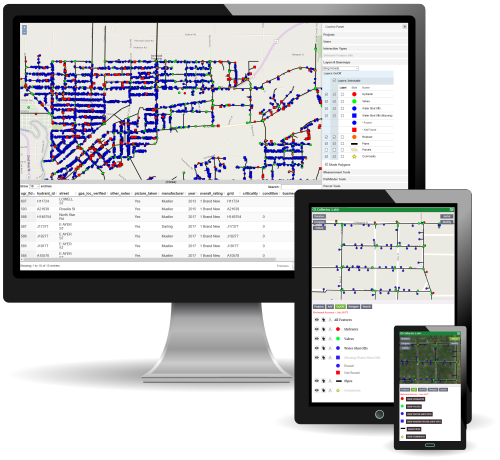

With more than 25 years of experience in civil engineering technology, surveying, data collection and software development, combined with more than 15 years of applying this real-world experience into GIS, Colligo will enhance and quite possibly revolutionize your current GIS process.

The Desktop, Mobile and Management tools work with Android, iOS and Windows and include these key features.


Colligo GIS: Desktop

The in-office side of Colligo GIS provides the typical tools you would find in a desktop GIS software as well as some unique items, all while being cloud-based for a maintenance free experience. Allowing users to access, update and analyze their GIS data in a centralized location.

  • Feature Creation with Unlimited Attribution (Point, Line, Polygon)
  • Searching, Reporting & Multi-Selection
  • Buffers & Measurement Tools
  • Interactive Parcel Mapping Tools
  • Reporting & Analysis
  • Coordinate System Transformations

Colligo GIS: Mobile

The field data-collection side of Colligo GIS provides field crews a streamlined interface to necessary GIS data in an automatic online/offline environment. With real-time editing, changes are automatically synced between field and office staff, keeping everyone updated with the latest content.

  • Stakeout
  • Simple-to-Use Creation and Editing Tools
  • Conditional Forms & Classifications
  • Geo-Referenced Image Overlays
  • Navigation Tools to Find Real-World Locations (Compass or Turn-By-Turn)
  • Compatible with Precision GPS Devices

Colligo GIS: Management

The administrator's portal of Colligo GIS allows complete control over projects, GIS layers and user access. Administrators can create GIS layers from scratch or import from other data sources. Define custom/conditional forms and styling per project.

  • Create/Manage/Assign Projects
  • Import/Export Datasets
  • Custom & Conditional Feature Styling
  • Create/Manage Image Overlays
  • Manage User Access on a Per-Project/Per-Layer Level

Flexible subscription pricing - To learn more, visit us at: ColligoGIS.com
Invalid password
Enter
Contact Sales

Looking for advice on a product or service? Speak with a member of our staff.

Need Help?

We're here to help you with all of your Bad Elf products. Browse recent FAQ's, our Knowledge Base, Glossary, and more.

Support

Our staff is ready to assist with your detailed questions.

Quick links

    Policies

    • Accessory Warranty
    • GPS / Electronics Warranty
    • MAP Policy (US)
    • Privacy
    • Returns
    • Shipping

    Connect with us on Social Media

    • Facebook
    • Twitter
    • Instagram
    • YouTube
    Use left/right arrows to navigate the slideshow or swipe left/right if using a mobile device
    • Choosing a selection results in a full page refresh.
    • Press the space key then arrow keys to make a selection.

    Shopping Cart

    No products in the cart.